Remote communities on the east coast of New Zealand's North Island were evacuated on Monday as tropical Cyclone Pam brought gales, torrential rains and huge waves to the coastal areas

Wellington: Remote communities on the east coast of New Zealand's North Island were evacuated on Monday as tropical Cyclone Pam brought gales, torrential rains and huge waves to the coastal areas.
The storm had passed through the north of the North Island and the city of Auckland with little impact, but it had been reclassified as "an intense tropical cyclone" early on Monday, Xinhua reported, citing a statement from the government's MetService weather bureau.
ADVERTISEMENT
The centre of the storm was 230km east of East Cape and it still has the power to bring severe weather.

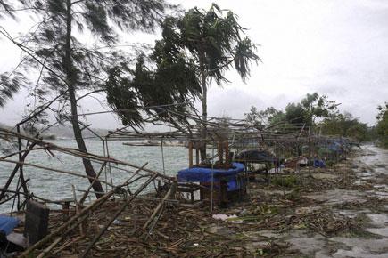
In this March 14, 2015, photo provided by World Vision, debris is scattered along the coast in Port Vila Vanuatu, after Cyclone Pam ripped through the tiny South Pacific archipelago. Packing winds of 270 kilometers (168 miles) per hour, Cyclone Pam tore through Vanuatu early Saturday, leaving a trail of destruction. Pic/ AP
More than 150mm of rain has fallen in the worst-hit Gisborne district in the 24 hours to 2 p.m. on Monday, with one area recording more than 200mm, and wind gusts reaching up to 145km per hour.
"Cyclone Pam is moving south-east and is expected to maintain its intensity, or may even intensify slightly, reaching the Chatham Islands around mid-day on Tuesday. A warning is now in place for severe gales, heavy rain and heavy swells for the Chathams," it said.
Schools in the Gisborne district were closed on Monday and power was out in many areas.
More than 40 people had been evacuated as a precaution against inundation by the sea and flooding, Gisborne civil defence emergency management controller Peter Higgs said in a statement.
Waves of up to nine metres were expected in parts of the region because of the high winds and swells, but these are expected to reduce to about three to four metres by mid-day on Tuesday.
Civil defence staff are considering further evacuations from low-lying areas.
"We have reports coming in of horizontal rain and a fierce sea rising rapidly," said Higgs.
 Subscribe today by clicking the link and stay updated with the latest news!" Click here!


