


A pizza delivery test may have failed in India, but the Unmanned Aerial Vehicle is helping chart rescue operations, gauge riot situations, predict crop conditions, aid border surveillance and of course, capture glamourous shots at social events. Ananya Ghosh gets a wide-angle view on what makes this device click

chetak square
You’ve seen them at weddings, those four-armed devices buzzing overhead, halting mid-air right before the bride and groom. You have also been awestruck by how it altered the cinematography of television seriese like Game Of Thrones, and movies such as The Wolf of Wall Street and The Hobbit Drones or Unmanned Aerial Vehicles (UAV) have stretched the panorama of aerial photography, as they help create wide-angle images, capture data for agriculture, wildlife conservation and enable remote monitoring of utilities such as transmission towers, gas pipelines, highways, railways etc.
![]()
A birds-eye view of Dadar East taken for a developer group to promote an upcoming property
ADVERTISEMENT
Thanks to their ability to rise up to a kilometre above the ground level, they also help track natural disasters, shoot sports events, with a renewed finesse that helicopters cannot match.
Earlier this week, researchers at IIT-Kanpur showcased three different kinds of UAVs as part of their project, and even companies such as Amazon, Google, Apple, Intel and Qualcomm have been researching in this technology for years.
In India, two types of drones are available in the market — small four-armed quadcopters, which are ideal for lifting light-weight cameras like the GoPro, and larger six to eight-armed drones that can easily lift the heavy 5D cameras.
Buy what you see
The real-estate industry has been extensively using drones for the past one year. Today, it is one of the biggest users of this technology. “To sell under-construction flats easily, builders often get photographs of the view clicked from certain heights to give the buyer a better perspective of the upper, unfinished floors,” says Pranshu Dubey, founder of PixelDo Media Pvt Ltd, a five-year-old company specialising in interactive media projects and panoramic photography.
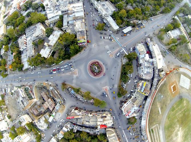
Aerial image for Chetak Circle taken for urban improvement department of Udaipur. PIC COURTESY/ PIXELDO
Interestingly, Dubey’s company created India’s first and largest digital interactive image for the government of Rajasthan — a 16-gigapixel panoramic image of Udaipur cityscape made up of 1,456 individual images on February 3, 2014 for the Udaipur government to help civic engineering and tourism in the city.
Closer home, Chief Minister Devendra Fadnavis’s dream project, Mumbai Next, an initiative to transform the country’s financial capital into a global financial and entertainment centre, launched in February this year. “We were roped in to provide aerial footage to help map the city,” says Mohit Gurjar of BrainWing, a company that provides drone-aided aerial cinematography services to the entertainment industry.
Superhuman feats
Ronnie Singh, founder and director of Shutter Grey media agency, says the drones have simplified their tasks. “Earlier one would have to climb trees, buildings and walls to capture aerial shots. Now, you just mount the camera on a drone and it does all the leg work,” says Singh, adding that this is the next step to aerial photography after helicopters, which had space constraints.
Sudhir Chaudhary says the ease with which one can maneuver a drone makes it a cinematographer’s darling. Having used it extensively during the shoot of Subhash Ghai's Kanchi (2014), he says, “Once the camera is mounted on the drone, you need one person to operate the drone while you can watch what the camera is sees on the monitor and click the shots you want with the help of a remote. Compared to a jib (a boom device with a camera at one end), the drone captures better angles. A helicopter would need a helipad to land, but a drone can land even on a piece of ply! Also, if we need a retake, it is easy to get the drone back up in the air within minutes.”
It has become quite a fad to use drones for video and photo shoots at weddings. Apart from the novelty factor, the drone helps capture pictures from angles where the human hand cannot reach. Photographer Rajdeep Banerjee from Jodi Clickers says “ It helps taking shots at places and moments where it is impractical for direct human presence - shots that move down from high up, zoom through little space, or from intimate spaces to panoramic shots. Also, there is no worry of people blocking our view. The drone captures what we on the ground may miss out,” says Banerjee.
Safety watch
Drones have played a crucial role in charting rescue operations in during the 2013 Uttarakhand floods, and gauged the situation of the 2014 Saharanpur riots. ideaForge, founded by a group of IIT Bombay graduates with the vision to inspire a surge of unmanned systems, created the world’s smallest and lightest full-featured autopilot in 2009.
Today, the company works closely with the Defence Research and Development Organisation (DRDO) labs and the defense and paramilitary forces. “We developed NETRAv2 UAV, a surveillance quadcopter that can be deployed for myriad activities such as search and rescue, riot control, border management for Border Security Force (BSF), counter insurgency operations (CRPF), infiltration monitoring (Indian Army),” says co-founder and CEO, Ankit Mehta.
Today one can buy advanced drones for R 1-2 lakh, while small ones are available for Rs 50,000. While rentals cost
Rs 20,000 a day onward, miniature models cost less than Rs 5,000.
Agriculture and politics
Aerial photography is also deployed by agricultural companies to predict crop conditions. “This helps decide the course of action for both remedial measures as well as production planning for industries that utilise agricultural produce,” says Tanuj Bhojwani, technical head of Quidich. This aerial photography company collaborated with a news channel during the last Assembly Elections and shot panoramic views of some of the most important constituencies such as Varanasi, Muzaffarnagar and Amethi.
Future perfect
“In future we will see auto-takeoff, auto landing, flying a pre-planned path and direction, cruise control, waterproofing, app based control on wifi, image detection, object detection etc,” says Gurjar. While Dubey is excited about the follow-me mode: “With this you would not require the knowledge to fly a drone. All you have to do is just install an app in your mobile and press a follow button and the drone will follow you and capture your activities. This will be an amazing tool to document adventure sports. Virtual reality is also getting involved with aerial imagery to give a complete new experience to the end user. All you have to do is wear the VR (virtual reality) glasses and it will give you the feel of flying like a bird!”
 Subscribe today by clicking the link and stay updated with the latest news!" Click here!
