


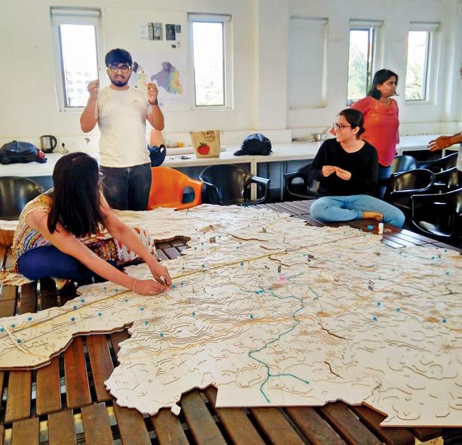
Students of the School of Environment and Architecture deconstruct climate, terrain and habitation of Mumbai's R Ward in a pilot project that looks at the city's flooding nightmare every monsoon

The group of architecture students, who conducted the study, gather on the bridge near the Borivli BMC office along the Dahisar river. Pic/Satej Shinde
 On a rainy day in 2051, when the mean sea level will rise by 0.5 metres, nearly 23 per cent of the urbanised areas of Borivli or R Ward, will be underwater. This will endanger the life of one in every five slum dwellers and one in seven residents overall. Going by the current habitation practices in Borivli, ongoing infrastructure projects, clogged drainage and outfalls into nullahs and the sea, there is likely to be an added reverse flow of water into the mainland. The scenario will be similar to what we witnessed on August 29, 2017, after 500mm rainfall.
It sounds like a doomsday prophecy, but is a prediction based on the Intergovernmental Panel on Climate Change (IPCC) report, which projects a 1.1 metre sea level rise for the year 2100. It's part of a homegrown pilot study executed by the final year students of the School of Environment and Architecture (SEA), in Borivli. The study, encapsulated in the book, Of Land Or Water?, focuses on the swatch extending from the foothills of Sanjay Gandhi National Park to the Manori creek. But its research methodology and perspective applies to all of Mumbai, a city that has seen an average of 250mm rainfall per day in the last six years.
ADVERTISEMENT
At the exhibition that shared the study findings with visitors
The study urges residents to think of short and long-term measures to deal with the temporal relationship between land and water, while sensitising architecture and urban planning professionals to their individual and cooperative responsibility of reimagining a resilient spatial form, which will survive the flooding.
In a city where planners and builders have reclaimed bays, creeks, floodplains, mangroves and watersheds, it is time that we thought of reverse ways of negotiating land for water. The SEA study appeals for a different type of 'reclamation' in which occupied land is intentionally and collectively released to make way for water. If the city doesn't show readiness for such a prearrangement, a large volume of water is likely to occupy the lived space, leading to catastrophic loss of life and property. On a map that indicates the current vulnerable areas of R Ward, the students have ethnographically documented the risen levels of flooding in relation to five units of height—ankle, calf, knee, waist and shoulder.
The physical inquiry into flooding, which took the 40-odd architecture students and faculty on specific flooded spots over a duration of seven weeks, forms the crux of the study. They have interviewed close to 50 stakeholders of three types—individuals/collectives that sustain their livelihood on the study site; the elected representatives, and the administrative/municipal leadership of the ward. While 15 stakeholders visited the college for interactions, others spoke from site locations. Citizens who suffered loss in the floods or those who had to vacate their hutments and run with their belongings on to the roads, have shared their fear of the monsoon. One slumdweller said, the mere noise of gushing water or rain falling on the metal roof is cause of panic in the family. In this context, Of Land Or Water? suggests collaborative ways for instituting relief and rescue spaces as well as trauma centres. There is evidence to prove, in R Ward (and elsewhere), that flood-affected citizens who are not given immediate healthcare and relief, suffer mental breakdown. The study recommends an immediate, mid-term and long-term investment in an infrastructural ecosystem, which gently handles people who suffer loss of property in unforeseeably torrential rains. This is in contrast to the current administration's knee-jerk declarations of ad hoc cash/kind packages for the monsoon-inflicted. SEA's research associate Vastavikta Bhagat, says that the study makes it fairly clear that business as usual is not going to get us out of this emerging crisis. "We cannot be digging wells to quench an instant thirst."
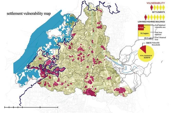
This map shows the total inhabited vulnerable area that will be prone to flooding (maroo), total urbanised area (yellow), areas affected by high tide (blue) and projected high tide line (dark blue). Map/Uday Mohite, Courtesy/Of Land or Water?
It's interesting that flooding in the city is examined not just in the context of rainfall, tidal action and rising sea levels, but also from the point of view of alterations done to natural topography, type of settlement, age/type of construction, existing natural water bodies, all of which have a formidable bearing on flooding. As the Borivli study shows, the public parks in Om Shanti Chowk have been concretised and raised, leaving no scope for water percolation. The redeveloped buildings on Kalpana Chawla Marg have raised their plinths which results in waterlogging in the older, neighbouring co-operative societies. Railway bridge culverts in the Poisar gaothan are clogged with garbage and debris.
These examples resonate with the reality outside of Borivli too, in almost every low-lying area of the city where dense settlements have impinged on water outlet routes. In fact, the North-South construct of the city conflicts the systemic flow of water from west to east. The railways and major arterial roads (SV Road, Western Express Highway and Link Road) obstruct the flow of water. Raised from their immediate surroundings, these key access strips ideally should have acted as bridges to facilitate passage of water, but they become dams that stop it. No wonder, all suburbs from Borivli to Bandra experience flooding along the SV Road stretch.
With the help of Geographical Information System, the SEA studio classifies R Ward into five macro watersheds—Dahisar river, Poisar creek, Manori creek and two of its tributaries. The riverine landscape, groundwater flow and degrees of wetness provided new access widows for the students. As the studio faculty, Ravindra Punde, puts it, "The watersheds and their natural subsystems became the basic unit of the study. It generated a different lens to view the urban form and achieve climate resilience."
The SEA studio's concept of a resilient Mumbai demands a rethink of urban policies, including the Development Plan. It links population pressure with infrastructural growth. This is not a politically convenient subject because the burgeoning population of Borivli (currently at 16 lakh) adds to the sheer number of buildings, vehicles, railway lines and flyovers, which obstruct the movement of water.
The study also points an accusing finger at the builders and designers of the ward who have not "responded to the logic of the terrain" but built buildings and gated townships that add to flooding woes. For the future of India's first-rate metropolis, for the life of a city that sets national precedents, we need to negotiate with the water that threatens to wash us away.
16 lakh
Borivli's current population
Sumedha Raikar-Mhatre is a culture columnist in search of the sub-text. You can reach her at sumedha.raikar@mid-day.com
Catch up on all the latest Crime, National, International and Hatke news here. Also download the new mid-day Android and iOS apps to get latest updates
 Subscribe today by clicking the link and stay updated with the latest news!" Click here!
