


A workshop will introduce children to map-reading through rare cartography of the city

Map of Bombay and the district prepared for Peshwa by the Peshwa's agent
![]() When the British acquired the seven islands of Bombay from the Portuguese that Catherine of Braganza brought as part of her marriage dowry to Charles II of England, the East India Company rented them from the British government and shifted their headquarters from Surat to Mumbai. The Company realised Mumbai's potential as a port city and embarked on projects to reclaim land from the sea, building roads to join the seven separate islands — this, we know, is how modern Mumbai was born. But what did the city look like then? What was the extent of the metropolis and what was the size and route of the roads? Where were the important buildings located? For these answers, a treasure of the historian is a map. Each map from another era becomes a document of history, telling stories of the time.
When the British acquired the seven islands of Bombay from the Portuguese that Catherine of Braganza brought as part of her marriage dowry to Charles II of England, the East India Company rented them from the British government and shifted their headquarters from Surat to Mumbai. The Company realised Mumbai's potential as a port city and embarked on projects to reclaim land from the sea, building roads to join the seven separate islands — this, we know, is how modern Mumbai was born. But what did the city look like then? What was the extent of the metropolis and what was the size and route of the roads? Where were the important buildings located? For these answers, a treasure of the historian is a map. Each map from another era becomes a document of history, telling stories of the time.
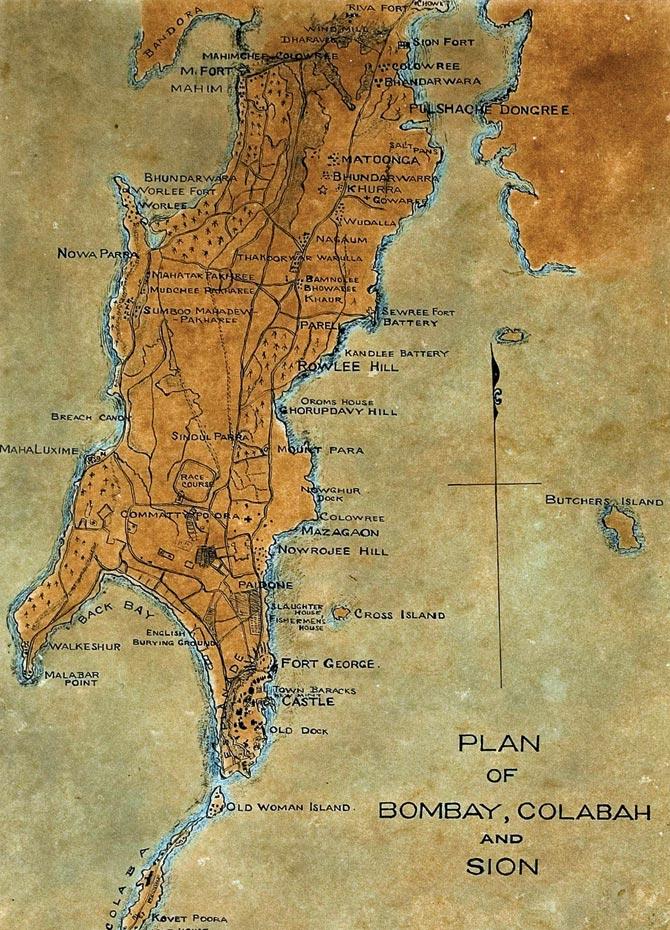
Plan of Bombay, Colaba and Sion
Make me a map
It is these stories that a workshop, Mapping Stories at Dr Bhau Daji Lad Mumbai City Museum, will share from its permanent collection of maps of Mumbai. Ruta Waghmare, curatorial associate at the museum says that the workshop has been designed for children to help them understand the history of Mumbai and draw connections between its past and the present. "The museum has a collection of rare, historical maps of Mumbai and currently, we are also showing an exhibition on contemporary Polish graphic design. A book of maps that introduces children to different countries, their histories and cultures through visual maps and illustrations will also be on display," she adds.
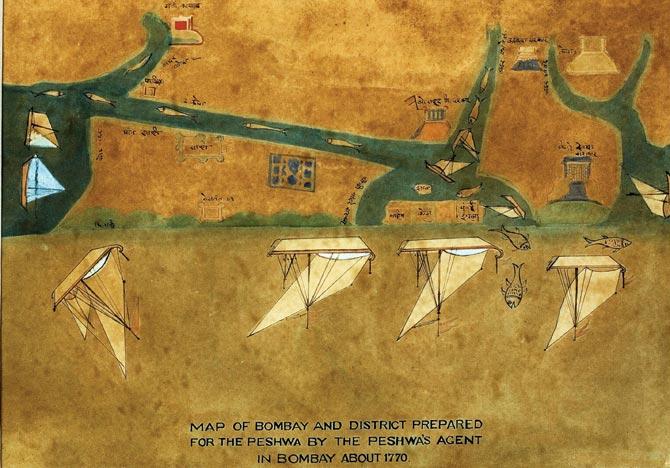
Map of Bombay and the district prepared for Peshwa by the Peshwa’s agent
The workshop will start with an interactive tour of the museum's collection of rare maps displayed in the Mumbai History gallery (known as the Kamalnayan Bajaj Mumbai Gallery). "Through these maps, the participants can explore Mumbai's evolving topography and history," Waghmare explains. In the end, the participants will create maps about Mumbai, using elements observed in the collection. They will also be encouraged to create maps, reflecting spaces and aspects of the city that they identify with.
Fryer’s Map of Bombay (1672). MAPS COURTESY/ bdl museum

Life of a city
The museum's permanent display includes rare maps (watercolour on paper) as well as 3D map dioramas made of terracotta. "Some of the interesting maps that will be highlighted during the workshop include one of Mumbai when the city was made of seven different islands, a map drawn by the Peshwa's agent of Mumbai in about 1770 and a survey map of the island of Bombay (1812-16) drawn on the orders of Captain Thomas Dickinson, an engineer with the East India Company," Waghmare says.

"These maps showcase the life of locals and the history of a city from late 18th to early 20th century. They also reflect how the city's topography changed from seven separate islands, known as 'Heptanesia', to today's large metropolitan city," she explains.
 Subscribe today by clicking the link and stay updated with the latest news!" Click here!


